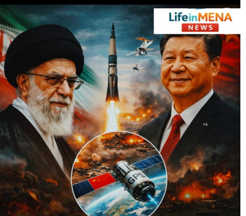
Iran Turns to China’s BeiDou Satellite System to Enhance Missile and Drone Precision
lifeinmena-Iran has reportedly begun replacing the United States-controlled Global Positioning System (GPS) with China’s BeiDou navigation satellite system to improve the accuracy of its missile and drone operations, a move analysts say could have significant strategic implications for the Middle East.
Iran Turns to China’s BeiDou Satellite System to Enhance Missile and Drone Precision
Defence experts suggest that the shift represents more than a technical upgrade. It reflects a broader geopolitical realignment and an emerging form of military cooperation between Beijing and Tehran that could reshape regional power dynamics.
Strategic shift in navigation technology
According to defence analysts, Iran’s decision to adopt the Chinese satellite network comes after years of concern over the reliability of GPS signals during periods of conflict. GPS, which is controlled by the United States military, can be disrupted or restricted in contested environments, potentially affecting the accuracy of weapons systems that rely on it.
China’s *BeiDou Navigation Satellite System, particularly its latest **BeiDou‑3* constellation, is designed to provide high-precision positioning and navigation services globally. Military analysts say its encrypted signals are considered more resistant to jamming or spoofing compared with conventional GPS-based systems.
As a result, the transition could significantly improve the accuracy of Iranian missile and drone strikes. Some defense observers claim that the error margin of certain Iranian missile systems may have been reduced to less than five meters when guided by the BeiDou network.
Eyes and Fists” cooperation
Security experts have described the emerging cooperation between China and Iran as an “Eyes and Fists” arrangement. Under this framework, China provides satellite-based positioning and intelligence capabilities—the “eyes”—while Iran deploys its missile and drone forces as the “fists”.
Analysts believe this arrangement could enhance Iran’s ability to target military installations across the region with greater precision. Access to satellite navigation data may allow Iranian forces to obtain more accurate, real-time positional information related to potential targets, including facilities associated with the United States and Israel.
However, independent verification of the full operational scope of the cooperation remains limited, and officials from Beijing have not publicly confirmed details of any military-related satellite support.
Lessons from recent conflicts
The shift toward BeiDou reportedly accelerated following Iran’s recent military confrontation with *Israel* in 2025, a brief but intense 12-day conflict that highlighted the growing role of advanced technology in modern warfare.
According to *Alain Juillet*, a former senior intelligence official in France, the experience convinced Iranian defence planners that relying on GPS during wartime posed strategic risks. Disruptions or interference affecting satellite signals could reduce the effectiveness of precision-guided weapons.
In response, Tehran is believed to have intensified efforts to integrate alternative navigation systems into its missile and drone infrastructure.
Advanced communication capabilities
One of the distinctive features of the BeiDou network is its built-in *Short Message Communication (SMC)* service. Unlike many satellite navigation systems, BeiDou allows users to transmit brief text messages through its satellites.
Defence analysts say this capability could enable commanders to maintain limited two-way communication with drones or missile systems even while they are in flight. Such communication could theoretically allow operators to update targeting data or adjust flight paths in real time.
Although the extent to which Iran is currently using this capability remains unclear, experts say it represents a potentially significant technological advantage in complex battlefield environments.
Deepening China–Iran strategic ties
The reported adoption of BeiDou technology is also seen as part of the broader strategic partnership between China and Iran*. The two countries signed a comprehensive 25-year cooperation agreement aimed at expanding economic, energy and security ties.
While the agreement primarily focuses on infrastructure and trade, analysts say it also opens the door for deeper technological and space-related collaboration.
China has invested heavily in developing its own satellite navigation infrastructure as an alternative to Western systems. By promoting BeiDou internationally, Beijing aims to reduce global reliance on GPS and expand its technological influence.
Implications for future warfare
Military experts say the growing importance of satellite navigation systems underscores how modern conflicts increasingly depend on space-based infrastructure.
Precision-guided weapons, reconnaissance platforms, drones and communication systems all rely heavily on satellite networks. As a result, access to secure and resilient navigation systems has become a critical component of national defence strategies.
Analysts warn that the spread of alternative satellite systems such as BeiDou could gradually change the technological landscape of warfare, particularly in regions where geopolitical rivalries are intensifying.
For the Middle East, the reported Iran–China cooperation may mark another step in an evolving strategic competition in which advanced technology—from satellites to artificial intelligence—plays an increasingly decisive role.